

Winnipeg, Manitoba, 16 May 2023 — Today, the Transportation Safety Board of Canada (TSB) released its investigation report (A22C0082) into the 18 September 2022 fatal occurrence in which a Cessna 172 aircraft operated by Airborne Energy Solutions Inc. collided with a communications tower near Shaunavon, Saskatchewan.
The TSB conducted a limited-scope class 4 investigation into this occurrence to advance transportation safety through greater awareness of potential safety issues. See the Policy on Occurrence Classification for more information.
The TSB is an independent agency that investigates air, marine, pipeline, and rail transportation occurrences. Its sole aim is the advancement of transportation safety. It is not the function of the Board to assign fault or determine civil or criminal liability.
Air transportation safety investigation report A22C0082
Collision with obstacle
Airborne Energy Solutions Inc.
Cessna 172, C-GZLU
Shaunavon, Saskatchewan, 6 NM SSW
18 September 2022
History of the flight
On 18 September 2022, the Airborne Energy Solutions Inc. Cessna 172 aircraft (registration C‑GZLU, serial number 17269719) was conducting a visual flight rules (VFR) flight consisting of multiple legs from Swift Current Airport (CYYN), Saskatchewan, to Estevan Regional Aerodrome (CYEN), Saskatchewan. The purpose of the flight was to gather electronic data on pipeline infrastructure for a client along a predetermined route that extended southeast of Shaunavon, Saskatchewan, then eastward to Estevan.
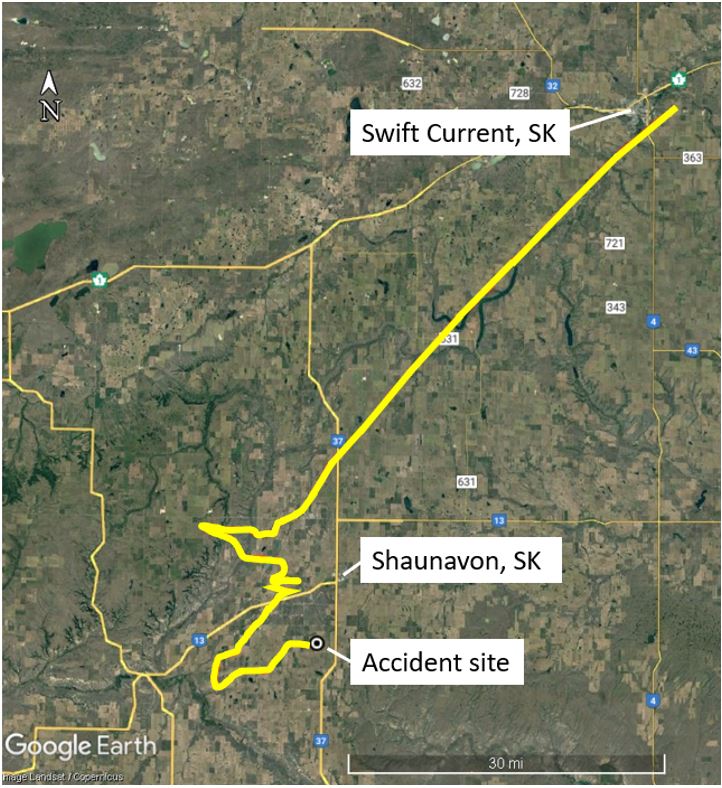
The aircraft departed CYYN at 0827Footnote1 with 2 pilots on board.Footnote2 At approximately 1003, the aircraft struck a communications tower approximately 6 nautical miles south-southwest of Shaunavon (Figure 1). The aircraft’s last recorded position on its flight tracker (at 1001:30) was 1.2 nautical miles west-northwest of the communications tower at an altitude of 3741 feet above sea level (ASL), which was 572 feet above ground level (AGL). The aircraft was destroyed. Both pilots were fatally injured. The aircraft’s 406 MHz emergency locator transmitter was destroyed on impact and no signal from it was received by the search and rescue satellite system.
Pilot information
The pilot flying, who occupied the left seat at the time of the occurrence, held a Canadian commercial pilot licence that had been issued on 14 September 2021. His licence was endorsed for single- and multi-engine aircraft. He held a valid Category 1 medical certificate, which had a restriction stating that “glasses must be worn.” He also held a Group 1 instrument rating. Records indicate that he had accumulated a total of 355 hours of flight time, 77 of which were on the Cessna 172 for Airborne Energy Solutions Inc. Records also indicate that he was well rested before the flight. According to information gathered during the investigation, there was no indication that the pilot’s performance was affected by medical factors.
The other pilot, who was monitoring the captured electronic data and assisting with navigation duties from the right seat of the aircraft, also held a Canadian commercial pilot licence. He had accumulated a total of 536 hours of flight time, 529 of which were on the Cessna 172.
Communications tower
The height of the communications tower was 3840 feet ASL, or 440 feet AGL. It was marked and lit in accordance with the Canadian Aviation Regulations.Footnote3 The tower was also depicted on the Regina VFR Navigation Chart (Figure 2). A VFR Navigation Chart is used by pilots flying in accordance with VFR and illustrates obstacles and other navigational information. The investigation was unable to determine if the pilots had consulted the chart while flight planning or during the flight.
![Magnified view of the Regina VFR Navigation Chart (AIR 5006), showing the depiction of the communications tower (Source: NAV CANADA, Regina VFR Navigation Chart [AIR 5006], 34th edition [February 2022], with TSB annotations)](https://www.tsb.gc.ca/eng/rapports-reports/aviation/2022/a22c0082/images/a22c0082-figure-02.jpg)
Client-specified flight parameters
The client’s aerial service provider job form listed several flight parameters to be followed while conducting flight operations. Among them was a specified flight height of 550 feet AGL (±50 feet). The aircraft was equipped with an altimeter, which indicates the aircraft’s altitude in feet ASL; however, it was not equipped with instrumentation that indicates the aircraft’s height in feet AGL.
Impact and wreckage information
The occurrence aircraft was travelling on a track of 88° true (T) when it struck the communications tower approximately 25 feet below the tower’s highest point. A 4-foot section of the aircraft’s right wing was shorn off and was discovered at the base of the tower. The fuselage then travelled approximately 240 m on a track of 174°T, before impacting the ground. A post-impact fire ensued, which consumed most of the remaining fuselage.